martyben Logo Martyben Contact Us
Contact Us
Aerial view of Jersika Hillfort archaeological site surrounded by forest with visible earthwork formations
10 min read Intermediate June 2026

Jersika Hillfort: History and What You'll See

Discover the medieval fortification that shaped the landscape. Learn what shaped Jersika's history and why it matters to local heritage today.

A Medieval Stronghold in the Heart of Daugava Valley

Jersika Hillfort stands as one of Latvia's most significant archaeological sites, and if you're exploring the ancient burial trails near Līvāni, it's a destination that shouldn't be missed. The hillfort sits strategically along the Daugava River, commanding views across the valley. It's not just a pile of earth — it's a window into medieval life during the 13th and 14th centuries when this fortress played a crucial role in regional defense and trade.

What you'll find here isn't reconstructed or overly polished. The earthworks remain largely as they were centuries ago. The site consists of multiple defensive ramparts, deep ditches, and elevated platforms that once supported wooden structures. You can walk the perimeter, trace the old defensive lines, and actually feel the strategic positioning that made this place important.

Close-up view of Jersika Hillfort's medieval earthwork ramparts showing layered defensive structures
Historical perspective of Daugava River valley showing terrain and strategic positioning of medieval hillfort

Understanding the Medieval Period

Jersika Hillfort's story goes back to when the Daugava River valley was a contested space. The fortification was built during the period when Livonian knights and local rulers competed for control of territory and trade routes. Construction likely occurred in the early 13th century, and the site remained occupied and modified through the 14th century.

The design shows sophisticated understanding of defensive principles. The ramparts weren't just random mounds — they're positioned to cover approaches from the river and surrounding territory. Deep ditches created barriers that'd slow attackers. Archaeological work has uncovered pottery fragments, tools, and remnants of structures, confirming that people didn't just defend here; they lived here. Families, craftspeople, and soldiers all occupied this hillfort during its active period.

Key fact: The hillfort spans roughly 2 hectares across multiple defensive platforms, making it one of the larger medieval fortifications in the region.

What You'll Actually See at the Site

The physical features that remain tell the story of medieval defense and occupation.

The Main Rampart

A prominent earthwork that rises roughly 4-6 meters above the surrounding terrain. Walking along its crest offers the best views across the Daugava valley. The slope is steep enough to have been a serious obstacle for medieval attackers.

Defensive Ditches

Multiple ditches run between and around the ramparts. These aren't shallow — they're deep enough to have seriously impeded movement. In medieval times, they likely held water or were lined with sharpened stakes. Today, you can trace their paths across the landscape.

Strategic Positioning

The site commands views of the Daugava River and surrounding approaches. You'll understand why medieval rulers chose this exact location. The elevation provides natural advantages that no amount of defensive construction could replicate.

Vegetation Patterns

Different plant communities grow on the ramparts versus the ditches versus the outer slopes. These variations actually help archaeologists understand soil conditions and past land use. You'll notice the differences as you explore.

Visiting and Practical Considerations

The site's open to visitors year-round, though the experience changes with seasons. Spring brings new growth that reveals the earthwork structure more clearly as vegetation returns. Summer offers the fullest views once leaves fill the trees — sounds counter-intuitive, but the forest canopy actually highlights the ramparts' silhouettes. Autumn brings clearer sight lines as leaves thin. Winter can make the paths muddy, but you'll see the underlying geology most plainly.

There's no visitor center or formal museum at the site itself. What you get is direct engagement with the archaeology. Bring good walking shoes — the paths aren't paved, and the terrain's uneven. The main rampart's accessible without technical climbing, though the slopes are steep enough to require balance and care. Most visitors spend 45 minutes to an hour exploring the site thoroughly, depending on pace and how long you linger at viewpoints.

Important Note

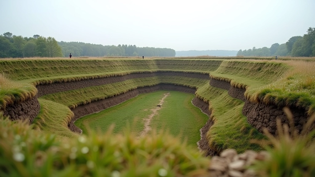
This site is an active archaeological location. The ramparts and ditches are part of the protected heritage site. While visitors're welcome to explore and walk the earthworks, removing artifacts or disturbing the soil isn't permitted. The information presented here's based on archaeological research and historical records. For detailed academic sources or current research projects, contact the local heritage authorities in Līvāni.

Understanding What You're Looking At

When you're standing on the rampart, you're literally walking on top of centuries of history. The soil beneath your feet contains remnants of the wooden palisade that once ran along the ridge. The ditches to either side once served as both physical barriers and water management systems. Medieval engineers weren't working with modern surveying tools, yet the site shows sophisticated planning.

The Daugava River below provides context for why this location mattered. Trade goods moved along the river — amber from the coast, furs from the interior, tin from distant sources. A fortification controlling river access could tax merchants and control movement. It wasn't just about military defense; it was about economic power. That's why the positioning matters so much. From the highest point, you can see the river curves and where boats would've slowed or had to navigate carefully.

Walking path along medieval rampart with forest surroundings showing terrain variation and defensive positions

Making the Most of Your Visit

Jersika Hillfort isn't flashy or heavily developed, and that's actually what makes it valuable. You're not viewing archaeology through glass cases or reading plaques written for tourists. You're walking the actual medieval landscape, feeling the slopes, seeing the river, understanding the strategic choices people made 700+ years ago.

Pair your visit with the other sites on the ancient burial trails. The combination gives you a fuller picture of how people lived and died in this region. Jersika shows you the fortified side — the military and political power structures. Other sites show you burial practices and religious beliefs. Together, they tell a much more complete story than any single location could.

Bring a camera if you're interested in photography. The ramparts offer genuinely striking views, especially from the highest points looking across the valley. The light changes throughout the day create different moods and reveal different details of the earthwork structure.